
Walk a Huber Heights Street
Begin with the land, not a name. Huber Heights spans Montgomery and Miami Counties, so the same municipal label does not select the right property, deed, tax, court, or election office. For a Montgomery-side address, the most reliable chain is address to parcel, parcel to legal description and recorded owner, then legal description or party name to the deed index. A Miami-side parcel needs Miami County systems instead. That county check prevents a familiar address from being attached to the wrong record trail.
- Enter the house number and street name in the Montgomery property search when the parcel is in Montgomery County, then select the matching parcel.
- Use the parcel map to check the location, parcel identifier, legal description, and nearby boundaries before drawing conclusions from the street name.
- Take the owner, legal description, instrument, or book-and-page clues to the Recorder. Search a buyer as grantee, then the prior seller as grantee for the earlier acquisition.
- Use the Ohio voter tool only to confirm a particular named person and county. It is not an address-first block browser.
- For an older household clue, ask the Dayton Room for reverse or criss-cross volumes under Huber Heights, Wayne Township, and the relevant Dayton or Miami Valley listing.
Each stop answers a narrower question. The property and deed route can document a parcel relationship; a historical directory can preserve an editorial listing for a given year. Neither source creates a complete current household list.
Huber Heights Street Search Fields
The Montgomery County MCRealEstate search has a precise address convention. Enter the number and bare street name, leaving off the direction and suffix. The official walkthrough also notes that variant forms such as 3rd and Third, or punctuation changes, can help when a first search misses. Its owner route uses LastName FirstName, while advanced options include comparison, date, Sounds Like, result-column, and saved-criteria controls. The live property cards were unavailable during the research, so their unobserved field layout is not assumed here.
| MCRealEstate route | Field or control | Documented use |
|---|---|---|
| Address | Number | Enter the street number. |
| Address | Street Name | Use the name only, without a direction or suffix. |
| Address | Filter, sort, order, results per page | Refine or arrange a result set; wildcard use is documented. |
| Owner | Owner Name | Use the required LastName FirstName format. |
| Owner | Tax Year | Choose the tax-year context for the owner search. |
The county's property-search walkthrough shows the entry convention used for this part of the Huber Heights street directory.
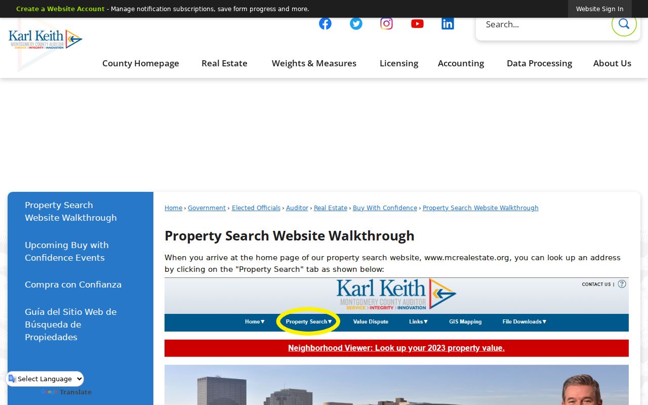
Following the prescribed entry format reduces false misses caused by a suffix or direction that the form does not want.
GIS Along Huber Heights Streets
After locating a likely parcel, use the Montgomery Auditor GIS to see the land context. The interactive viewer supports Address and Zone searching, Street 1 and Street 2 intersection searching, parcel selection, buffer distances in feet or miles, measuring, and selection from results. It also supports a Recorder document viewer with Name/Alias, Plat Book/Page, Document Type, As Built, and Map ID queries. These tools are useful for distinguishing a target parcel from an adjoining lot, a road, or a common area.
GIS is map evidence, not ownership proof. Center the target, click the parcel, preserve its identifier and legal description, then verify the owner or transfer through the Auditor and Recorder. The county warns that it provides no warranty for errors or interpretations. A map can show a nearby parcel; it cannot prove who presently occupies it.
For a street that crosses an uncertain county edge, the situs county and legal description are the deciding clues. The City name on an envelope or a nearby post office does not replace that check.
Huber Heights Street Deed Chain
Montgomery County's property guide places deeds from 1805 to the present with the Recorder. The Recorder's Information Search System, or RISS, permits no-cost guest searching after accepting its disclaimer. Search By Name with a last or firm name and index type, or use the By STR/legal-description route. That route has a Properties menu that includes HUBER HEIGHTS, plus index type, optional section, township, range, party, date, and sort fields.
A careful chain moves from the current recorded buyer to the acquisition document, notes the prior seller, then searches that seller as a buyer for the earlier transfer. Compare recording date, lot or block, subdivision, parcel, and legal description at every step. A seller may own more than one property, and the legal description is the safeguard against following the wrong same-name party. The Recorder counter and the Records Center remain useful for historical verification beyond a web result.
Montgomery's Treasurer is another address route. Its tax search accepts a tax year, parcel ID, owner name, or street number and street name, and advises completing one route at a time. Parcel IDs begin with a capital letter in the county's format.
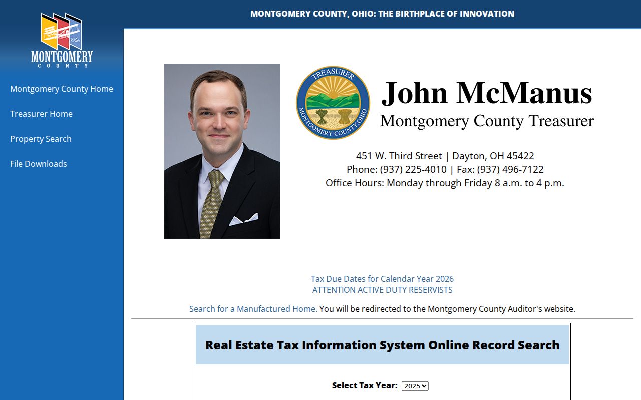
Using one Treasurer route at a time makes it easier to see whether a nonmatch comes from the address entry, the owner format, or the parcel identifier.
Huber Heights Street Records in Miami
A Huber Heights street in the northern part of the city, including the Carriage Trails area, may require the Miami County Auditor and Recorder rather than Montgomery systems. The Miami Recorder's AVA and Laredo search information describes name or book-and-page access for documents from 1998 forward and book-and-page work for 1980 through 1998. Earlier work relies on scanned geographic, name, and Green Abstract index books.
The Miami Recorder cautions that some documents lack a parcel or address. Start with a party, book and page, or geographic-index clue, then verify it against the legal description and the Miami Auditor tax map. The office says name-index scanning is still incomplete and excludes the 1917 through 1920 name books. A street directory search in Miami County is therefore more index-driven than a simple address query.
Carriage Trails, Parktown, and the firehouse area north of I-70 can be Huber Heights locations with a Tipp City mailing address. Confirm the parcel's county through the Auditor or tax map before choosing the Recorder, rather than relying on the postal city.
For a non-watermarked copy, the Recorder accepts requests by email at recorder@miamicountyohio.gov, and the counter provides the other document and historical-index path. This is a useful contrast with Montgomery RISS guest access, but neither county's online result should be treated as a complete historical chain by itself.
Huber Heights Street Permit Evidence
Address evidence can also be municipal. Huber Heights zoning and code records cover zoning permits, published annual permit lists, violation reports, and a parcel zoning map. The city directs construction and inspection work to the Montgomery County Building Department, or MCBD. Its split matters: city records can address zoning or code activity, while electrical, plumbing, HVAC, structural, roof, utility, and other building work may be on the county side.
A focused request should give the address, date range, and permit category. A permit can help date a project or identify an applicant, contractor, or property contact. It does not establish ownership or current occupancy. An absent city permit can simply mean the work was interior or was handled by MCBD.
The MCBD building portal is the county-administered branch of this Huber Heights street directory trail.

Pair a permit result with the parcel and deed record before using it to interpret the history of an address.
Huber Heights Street Record Coverage
Several public sources can be keyed to an address, but they do not answer the same question. The following coverage view keeps the property, map, transfer, permit, and historical-listing roles separate.
| Address source | Primary keeper | Useful result | Access path |
|---|---|---|---|
| Property or tax record | Montgomery Auditor or Treasurer, or Miami Auditor | Parcel, deeded owner or taxpayer, situs, mailing clue, legal description | Web search and office, after confirming county |
| Parcel GIS | County Auditor GIS | Parcel geometry, nearby boundaries, map context | Interactive map, then Auditor and Recorder confirmation |
| Deed, plat, or mortgage | Recorder in the situs county | Grantor, grantee, legal description, recording date | RISS or AVA/Laredo, plus counter or index books |
| Zoning or building record | Huber Heights and MCBD | Project, permit, violation, or inspection context | Published report, targeted city request, or MCBD route |
| Reverse directory | Dayton Room | Historical named address listing | Ask for the pertinent volume and its key |
Ohio's voter lookup requires a first name, last name, and county. It can corroborate a particular registration when available, but it is not an additional street-browse row in the table. Protected registrations are excluded.
Huber Heights Street Record Terms
County records use several land terms that make an address search more precise. Recording each one beside the street address helps reconcile a map result with a deed or a later historical directory entry.
- Parcel
- A defined piece of land in the county tax and map system, usually identified by a parcel number.
- Situs address
- The location where the land sits. It is different from a correspondence address used for tax mail.
- Plat
- A recorded map that lays out a subdivision, lot, block, street, or other land division.
- Criss-cross directory
- A reverse directory arranged by address rather than by a person's name, useful for a historical address listing.
Mailing information is a clue for correspondence, not a residency finding. A recorded owner may be a trust, estate, company, or person whose tax mail goes elsewhere.
Historic Huber Heights Address Listings
For older address research, the Dayton Room is the relevant library path. Ask for reverse or criss-cross volumes serving Huber Heights, Wayne Township, and the broader Dayton or Miami Valley area. Exact local years must be confirmed with the volume or catalog, because the public catalog material reviewed did not establish a complete Huber Heights run. A printed entry can include a named person and address, with abbreviations whose meaning depends on that edition's key.
Before 1981, the community was Wayne Township, and the City Charter took effect in 1984. A missing Huber Heights street directory entry from an earlier era is a reason to retry Wayne Township, the subdivision, lot, block, or county legal description. The historical volumes are treated in more detail with the Huber Heights city directory collections.
Pair a directory listing with a deed date, census record, map, or obituary citation rather than treating the listing as a permanent address record. This keeps the date of each source visible and avoids turning a historical lead into a current-residency claim.
Limits of Huber Heights Street Directories
A Huber Heights street directory can tie a public record to land, a transfer party, a project, or a dated directory listing. It cannot disclose every person living at an address. Renters, household members, utility customers, motor-vehicle addresses, protected voters, and Safe at Home participants do not become a public street list through these sources. A map alone is also not evidence of ownership, and a deeded owner is not automatically a current occupant.
Use address records for lawful personal, family-history, property, civic, or safety questions. Keep the source, date, and county beside each finding, and confirm a material fact with the office that holds the record.
Note: A missing public result may reflect the wrong county, an indexing limit, a historic name change, or a protected record rather than an absence.